
What if I told you that 300 feet beneath the surface of 8 states, in almost exactly the same place the dustbowl happened, there’s a 2.9 billion acre-feet, or 978 trillion gallons of water just sitting there, resting among the sand, gravel, silt and clay it’s mixed with.
That’s like laying an entire Lake Huron beneath the surface. The difference? It’s actually an aquifer.
So, real quick definition of an aquifer: “An aquifer is an underground layer of water-bearing permeable rock, rock fractures or unconsolidated materials (gravel, sand, or silt)” (wikipedia)
This specific aquifer is the largest in North America and one of the largest in the world.
It was discovered in 1898 by N.H. Darton, and named after the town it was discovered in, in Nebraska.
It’s been there for 3-6 million years, going all the way back to when it was an ancient river system. The material it saturates was part of that river system when the tectonic plates were still moving.
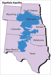
It ranges anywhere from 1-1500 feet deep and covers 174,000 sq. miles from S. Dakota to the south of the Texas Panhandle. The kicker is that while many were struggling their way through the 10 year dustbowl in the 40’s, this gigantic body of water was laying right beneath their feet.
Eventually they learned how to tap into it, drilling 300ft down, creating wells and large “pumps and taps” that farmers could hook up their irrigation system to for their crops. This helped to end the dustbowl.
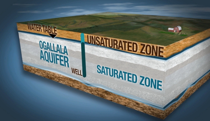
The problem is that the Ogallala is not a replenishing aquifer. Rainwater in these areas either drains off the surface or evaporate from the ground and plants. Every year only ONE inch is added to the actual aquifer, while in the meantime farmers are using hundreds of gallons per day to water their crops or supply drinking water to over 2,000,000 people. At that rate, it would take 6000 years to replenish it.
Since the 1940’s, the aquifer has dropped 300 ft in volume. In some places it went from 240ft to just 80ft in fifty years. In Texas, it’s completely tapped out and many of the grain elevators in the panhandle have closed down because of the inability to grow and water their crops. If the aquifer keeps getting drained, eventually the farming land that depends on it will cease to grow anything as well.
20% of the corn grown in the US and overseas depends on this region. Farmers going back to the 1800’s have depended on this region. While it’s not too late, they are doing anything they can to conserve the aquifer, but even that’s not going to be enough to save it, as so many people depend on it.
In the 2000’s the Transcanada pipeline had planned to run across the aquifer and so many opponents to the TCPL said this wasn’t a smart move incase of a spill or a leak, which could get into and contaminate the aquifer. People who were all for the TCPL mentioned many other pipelines that are in the same area that don’t have any issues.
Either way, there are non-profits that help to save the aquifer, including the North Planes Groundwater Conservation District.
There’s many ways we can help the aquifer, including donations, but one of them is to remove dependence or need for corn products and byproducts. This creates a double-edged sword though, since that’s a main crop for farmers in the area. However, conservation of water in any capacity is always beneficial to human kind.
If interested in helping, there are many links that can be found, including the ones* below.
fixingourfood.wordpress.com
prezi.com (article by Megan Peddle & NBC learn)
USDA.gov
*www.Northplainsgcd.org
Wikipedia.com
Nebraskaeducationonlocation.org
*Support AGWT | American Ground Water Trust
*www.greatnonprofits.org
As always, you can find my fictional novel, The Pecan Trees on Amazon, or in the home page of my website, www.Authorkristinamoore.com
